

Features.
Sketch your own layouts
Pick and customise readymade components from our library of houses, streets, parking and green spaces, to create your own architectural site layout.
Our library includes a range of NDSS compliant house types, customisable flat floorplates, a range of types of parking spaces, four different street configurations as well as components for gardens, green space and biodiversity areas
See all your constraints in one place
Gone are the days of having to trawl through Local Authority websites to find your conservation areas, listed buildings and flood zones, then trying to figure out where your site is in low resolution maps. We show you what you need to know at the click of a button.
Our data comes straight from the Department for Communities and Levelling up, so you know what you’re looking at is official and up to date.
Get instant build costs
Do you have your own construction costs per square metre? Add them to Blocktype and we’ll automatically multiply them by the total Gross External Area of the buildings on your site so you can see your total construction cost. You can even have different construction costs for different buildings to accommodate for a wide range of builds.
If you change the mix or the design, your costs will be automatically updated.
Calculate your Gross Development Value
Your site's GDV is probably the most important figure you need to know. Blocktype calculates this automatically. If you have your own values, you can add them to Blockype, and that’s what we’ll use.
Add a storey, change the mix, and watch how your GDV changes.
Know your Community Infrastructure Levy
Working out CIL can be time consuming and frustrating, once you find the most-up-to-date Local Authority CIL schedule you need to find the relevant maps with the zones, and try and identify where your site is.
We’ve aggregated all CIL schedules and maps and added them to Blocktype, so as soon as you drop a building on the site, you will know what your CIL liability will be.
Population and child yield
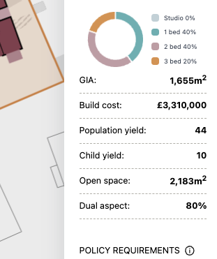
Know the population and child yield of your proposed development so you can work out infrastructure requirements.
Parking space requirements

We’ve collected parking policies from Local Authorities across England so we can calculate your minimum or maximum number of parking spaces your development should have.
See ownership boundaries
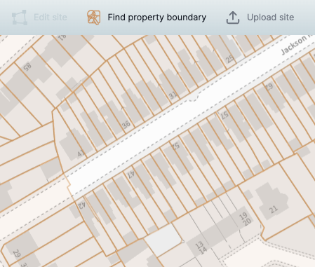
We access Land Registry data so you can see and use land ownership boundaries to create your site and understand any delivery challenges.
Watch Blocktype in action
Still have questions? Book a demo!
If you still have questions on how Blocktype can transform your workflow book a demo with a member of the team.